How to Read a Bortle Scale Map: Your Complete Guide
The Bortle Dark-Sky Scale is our primary system for measuring sky darkness. This mission briefing calibrates your understanding of the 1-9 scale, mapping exactly how light pollution impacts what your eyes—and your camera sensors—can actually see from the field.
DH Research Lab
Data & Editorial Board
Expert Tested Gear & Affiliate Disclosure
This guide contains affiliate links. As an Amazon Associate, we earn from qualifying purchases.
01Understanding the Bortle Scale
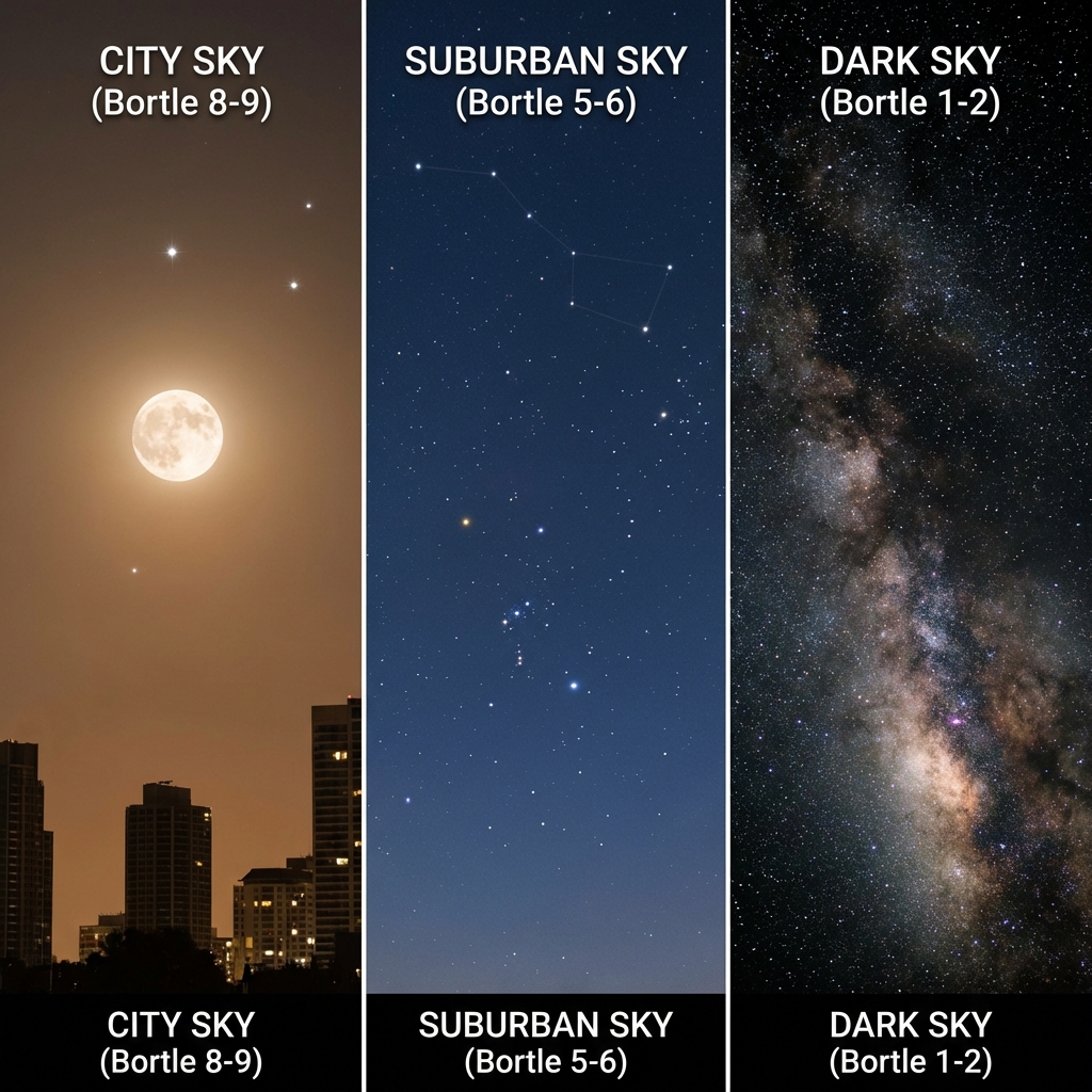
The Bortle Dark-Sky Scale was created by amateur astronomer John E. Bortle in 2001. It measures sky brightness on a scale of 1 (darkest) to 9 (brightest city center), based on what you can actually see with the naked eye.
| Class | Name | What You'll See |
|---|---|---|
| 1 | Excellent | Zodiacal band, gegenschein, M33 easily visible |
| 2 | Typical Dark | Milky Way casts shadows, airglow visible |
| 3 | Rural | Milky Way shows structure and dark lanes |
| 4 | Rural/Suburban | Milky Way visible but lacks detail |
| 5 | Suburban | Milky Way washed out, only brightest parts visible |
| 6 | Bright Suburban | Milky Way only visible near zenith |
| 7 | Suburban/Urban | Milky Way invisible, only bright stars visible |
| 8 | City | Few constellations recognizable |
| 9 | Inner City | Only Moon, planets, and brightest stars visible |
Check your location's Bortle class on our Dark Sky Map.
The Magic Threshold
02What Those Map Colors Mean
Light pollution maps use color gradients to represent sky brightness. While exact colors vary by map provider, here's the typical scheme:
Standard Color Key:
- 🔵 Blue/Black (Bortle 1-2) — Pristine dark skies
- 🟢 Green (Bortle 3) — Rural excellence
- 🟡 Yellow (Bortle 4) — Good stargazing
- 🟠 Orange (Bortle 5-6) — Suburban skies
- 🔴 Red (Bortle 7-8) — Urban glow
- ⚪ White/Magenta (Bortle 9) — City center
Our Dark Sky Map uses NASA VIIRS satellite data to create precise, up-to-date light pollution overlays. The satellite measures actual light escaping into space, giving you real-world brightness levels.
VIIRS Data
NASA's satellite measures visible light from 500 miles up.
Updated Monthly
Maps reflect recent urban changes.
Ground-Truthed
Correlates with observer reports.
03Reading the Map for Your Location
Here's my step-by-step process for finding a stargazing spot:
Step 1: Find Your Starting Point Open our Dark Sky Map and zoom to your city. Note your home's Bortle class—this is your "baseline" for comparison.
Step 2: Look for Dark Pockets Zoom out and identify the nearest blue or green zones. In most of North America and Europe, you'll need to travel 60-90 minutes from a major city to reach Bortle 4.
Step 3: Trace the Route Follow roads from your location toward the dark zone. Look for:
- State/national parks (often have parking and facilities)
- Reservoirs and lakes (water creates natural buffer zones)
- Mountain overlooks (altitude helps, and you're above valley lights)
Step 4: Check the Terrain Dark maps show average brightness. A technically dark area surrounded by cities on three sides may have a limited view. Use satellite view to verify horizon obstructions.
Step 5: Verify Current Conditions Our dashboard shows real-time cloud cover, seeing, and transparency—not just static light pollution data.
04Beyond Bortle: Other Factors That Matter
A Bortle 3 site with bad conditions can be worse than a Bortle 5 with perfect transparency. Here's what else to check:
Transparency How clear is the air? Humidity, wildfire smoke, and dust all scatter light. High transparency nights make even moderate Bortle sites shine.
Seeing Atmospheric stability affects planetary and lunar detail. Turbulent air makes stars twinkle beautifully but ruins high-magnification views.
Cloud Cover Obviously, clouds block stars. But thin high cirrus can scatter light from distant cities, degrading otherwise dark skies.
Moon Phase A full moon at a Bortle 1 site is still a washed-out sky. Always plan around moonrise/moonset times. The week around new moon is prime time.
Light Domes Cities create "domes" of light visible from 50+ miles away. Even from a dark site, a city on the horizon will wash out low-altitude objects in that direction.
Our Dashboard Shows It All
05Practical Tips for Map Users
Know Your Light Tolerance For casual naked-eye stargazing, Bortle 5 is often fine. For Milky Way photography, you want Bortle 4 or darker. For serious deep sky imaging, aim for Bortle 3 or better.
Edge Zones Are Okay You don't always need to drive to the dark core. The edge of a green zone, where it meets yellow, is often accessible and still excellent.
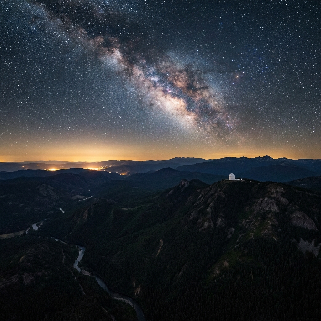
Altitude Helps Higher elevation = less atmosphere = better transparency. Mountain sites often "punch above their weight" on the Bortle scale.
Direction Matters If you can't escape the city entirely, position yourself so the city is behind you. The sky in the opposite direction will be 1-2 Bortle classes darker.
Scout by Day Visit your stargazing spot during daylight first. Check for:
- Safe parking
- Line-of-sight obstructions
- Cell service (for emergency)
- Flat ground for setup
06Using Our Dark Sky Map
Our Dark Sky Map is specifically designed for astronomers and astrophotographers. Here's how to get the most from it:
Features:
- Toggle light pollution overlay on/off
- See your current location's Bortle class
- Check real-time weather and cloud cover
- View ISS and Starlink satellite passes
- Monitor aurora Kp index for northern lights
Quick Tips:
- Allow location access for instant local data
- Click anywhere on the map for point-specific info
- Use the sidebar for detailed conditions
- Save favorite locations (Premium feature)
Start planning your next dark sky adventure now—open the map.
Celestron SkyMaster 15x70 Binoculars
“Perfect dark-sky companions for wide-field Milky Way scanning.”
RATIONALE
Large 70mm objectives gather enough light to reveal structure in the Milky Way even from Bortle 5 sites.
Frequently Asked Questions
Q:What is a good Bortle class for stargazing?
Bortle 4 is the sweet spot for most stargazers. It's dark enough to clearly see the Milky Way and many deep sky objects, but accessible within 1-2 hours from most cities. For astrophotography, Bortle 3 or darker is recommended.
Q:What do the colors on a light pollution map mean?
Light pollution maps use colors to indicate sky brightness: Blue/Black = pristine dark skies (Bortle 1-2), Green = rural darkness (Bortle 3), Yellow = good stargazing conditions (Bortle 4), Orange = suburban skies (Bortle 5-6), Red = urban glow (Bortle 7-8), and White/Magenta = inner city (Bortle 9).
Q:How far do I need to drive to escape light pollution?
From most major cities in North America and Europe, you'll need to travel 60-90 minutes to reach Bortle 4 skies. For truly dark Bortle 2-3 skies, expect 2-3 hours of driving.
Q:Can I see the Milky Way from a Bortle 5 location?
Yes, but it will be faint and lack detail. At Bortle 5, only the brightest parts of the Milky Way core are visible. For the full experience with dark lanes and structure, seek out Bortle 4 or darker skies.
Q:What is the difference between Bortle 1 and Bortle 9?
Bortle 1 represents the darkest skies on Earth where the zodiacal light, gegenschein, and M33 galaxy are visible to the naked eye. Bortle 9 is inner-city conditions where only the Moon, planets, and a handful of the brightest stars are visible due to extreme light pollution.
Don't waste a clear-night chance
Get the field checklist, then use DarkestHour to decide if tonight's sky is actually worth your time, setup or travel.
Learn first. Decide with the map.
DarkestHour guides are free trust builders. Use them to understand conditions, then use Pro for saved spots, alerts and best-night decisions.
Find Your Darkest Sky
Use our real-time satellite maps to find locations with zero light pollution.
Launch Interactive MapYour Learning Roadmap
You've mastered the beginner basics. The next logical step in your technical progression is mastering intermediate acquisition.
MANDATORY FIELD EQUIPMENT
Celestron NexStar 8SE
The gold standard for deep-sky observation. 203mm aperture for maximum light gathering.
ZWO Seestar S50
Fully robotic imaging system. Perfect for urban environments and rapid deployment.
Peak Design Travel Tripod
Zero-latency stability for long exposure astrophotography. Carbon fiber construction.
Continue Your Research
15 Best Dark Sky Reserves & Sanctuaries Global Guide
Escape light pollution at the world's finest dark sky spots. Discover the top 15 IDA dark sky reserves and plan your ultimate astrophotography trip.
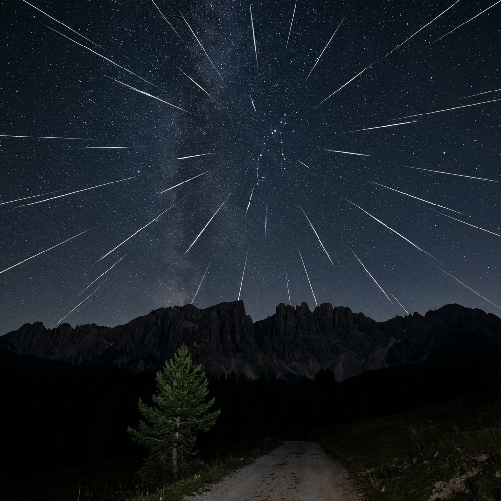
Meteor Shower Calendar 2026: Don't Miss These Events
Your complete guide to every major meteor shower in 2026. Find peak dates, hourly rates (ZHR), and expert photography tips for each event.
Total Lunar Eclipse March 2026: Blood Moon Guide
The last Blood Moon until 2028! Complete guide to the March 2026 total lunar eclipse with viewing times, photography settings, and essential gear picks.
End of Dossier • Research Complete